-40%
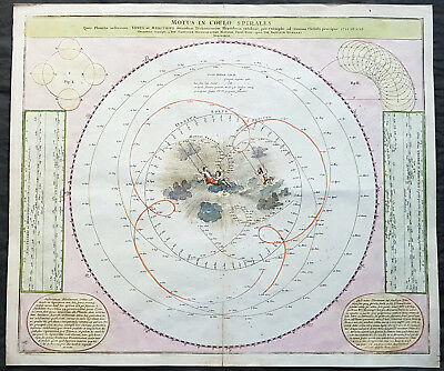
1716 Doppelmayr Antique Celestial Chart Tycho Brahes Motion of Venus & Mercury
$ 343.2
- Description
- Size Guide
Description
contact usebay profile
ebay store
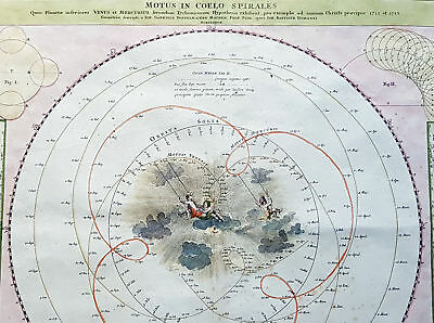
Motus In Coelo Spirales : Quos Planetae inferiores Venus et Mercurius secundum Tychonicorum Hypothesin exhibent, pro exemplo ad annum Christi praecipue 1712 et 1713 ; Cum Privilegio Sac. Caes. Maiestatis / Geometri`ce descripti a Ioh. Gabriele Doppelmaiero Mathem. Prof. Publ. operâ Ioh. Baptistae Homanni
Cartographer :
- Doppelmayr, Johann Gabriel 1677 - 1750
Date:
- 1716
Size:
- 24 1/2in x 21in (625mm x 535mm)
Ref#:
- 82033
Condition:
- (A) Very Good Condition
Description:
This fine hand coloured original copper-plate engraved antique astronomical chart showing the Geocentric motion of the inner planets of Mercury and Venus according to the Tychonic hypothesis for the years 1712 and 1713 was first published in Homanns
Atlas von hundert Charten
in 1712 & the
Grossen Atlas
in 1712. In 1742 Doppelmayr collected most of the Astronomical charts he had prepared over the years for the Homann publishing firm and published The
Atlas Coelestis
with 30 Astronomical Plates, including this one.
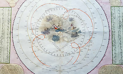
This chart was published according to the famous Tycho Brahes cosmological system that described the complex movements of Venus and Mercury as viewed from earth. The center of the chart is filled with a delightful scene of cherubs swinging through the clouds. Two text panels at lower corners describe the movements of the planets.
General Definitions:
Paper thickness and quality: - Heavy and stable
Paper color : - off white
Age of map color: - Original
Colors used: - Yellow, green, blue, pink
General color appearance: - Authentic
Paper size: - 24 1/2in x 21in (625mm x 535mm)
Plate size: - 23in x 19 1/2in (585mm x 495mm)
Margins: - Min 1in (25mm)
Imperfections:
Margins: - None
Plate area: - Bottom centerfold re-joined
Verso: - None
Background:
Doppelmayrs
best-known astronomical work is his
Atlas Coelestis in quo Mundus Spectabilis et in eodem Stellarum omnium Phoenomena notabilia, circa ipsarum Lumen, Figuram, Faciem, Motum, Eclipses, Occultationes, Transitus, Magnitudines, Distantias, aliaque secundum Nic. Copernici et ex parte Tychonis de Brahe Hipothesin. Nostri intuitu, specialiter, respectu vero ad apparentias planetarum indagatu possibiles e planetis primariis, et e luna habito, generaliter e celeberrimorum astronomorum observationibus graphice descripta exhibentur, cum tabulis majoribus XXX,
published in 1742 by the heirs of Homann in Nuremberg.
In this atlas, Doppelmayr collected most of the astronomical and cosmographical plates which he had prepared over the years for the Homann publishing firm and which had appeared in several of their atlases. These earlier atlases allow us to infer approximate dates for the design and preparation of many of Doppelmayr’s cosmographical plates.
The earliest ones are plates 2 and 11 as they were already included in Homann’s first atlas, the
Neuer Atlas bestehend in auserlesenen und allerneusten Land-Charten ueber die gantze Welt, und zwar erstlich nach Astronomischer Betrachtung der Bewegung des Himmels in dem Systemate Copernico-Hugeniano, dann auch nach der nturlichen Beschaffenheit und geographischen Eintheilung der mit Wasser umgebenen allgemeinen Erd-Kugeln in ihre besondere Monarchien, Koenigreiche, Staaten und Laender
(Nuremberg, 1707).
Plates 3 and 7 to 10 were first published in Homann’s
Atlas von hundert Charten
(Nuremberg, 1712), whereas plates 1, 4 and 15 to 25 can be dated between 1716 and 1724 as they were not included in Homanns
Grossen Atlas
(Nuremberg, 1716), but are mentioned in Hagers list of plates sold by Homann at his death in 1724.
The plates depicting the constellations (nrs. 16 to 25) were probably prepared and engraved in the early 1720s as the
Atlas Portatilis Coelestis, oder compendiose Vorstellung des gantzen Welt-gebudes, in den Anfangs-grunden der wahren Astronomie
(1723) of Johann Leonard Rost refers to a set of celestial hemispheres drawn by Doppelmayr. The choice and the style of the constellation figures on these plates is based on the
Firmamentum Sobiescianum sive Uranographia
(Danzig, 1687) of the Polish astronomer Johannes Hevelius, who also avoided the use of Bayer’s Greek letters for identifying the individual stars, and they were clearly executed before the publication of John Flamsteeds star catalogue (London, 1725) and star atlas (London, 1729).
Doppelmayr, Johann Gabriel 1677 - 1750
Johann Gabriel Doppelmayr (also spelled Doppelmaier or Doppelmair) was the son of the Nuremberg merchant Johann Siegmund Doppelmayr (1641-1686) and was born on 27 September 1677 (many early sources incorrectly give his year of birth as 1671). His father had an interest in applied physics and was one of the first to design a vertical vacuum air pump in Nuremberg.
Doppelmayr enrolled at the Ägidiengymnasium in 1689 and after completing his studies in 1696 enrolled at the nearby university of Altdorf to study law which he completed in 1698 with a dissertation on the Sun. He then attended lectures on mathematics and natural philosophy by Johann Christoph Sturm (1635-1703) which he completed in 1699 with his dissertation De visionis sensu nobilissimo, ex camerae obscurae tenebris illustrato. He continued his studies on physics and mathematics at the university of Halle where he also learned French and Italian.
In September 1700, Doppelmayr traveled to Berlin and from there, through Lower Saxony, to Holland where he visited Franeker and Amsterdam on his way to Utrecht where he stayed for a couple of months to continue his studies on physics and mathematics and to master the English language.
In April 1701, Doppelmayr went to Leiden where he stayed in the house of the astronomy professor Lothar Zumbach von Koesfeld and learned (probably in the Musschenbroek workshop) how to grind and figure telescope lenses. He then traveled to Rotterdam and in May to England where he visited Oxford and London.
After returning to Holland in the end of 1701, Doppelmayr spent another five months in Leiden, where he followed astronomy lessons from Lothar Zumbach von Koesfeld. After visiting Utrecht, Deventer, Osnabrück, Hannover, Kassel, Marburg, Gießen, Wetzlar and Frankfurt, Doppelmayr returned to Nuremberg in August 1702 and was appointed professor of mathematics at the Ägidiengymnasium in 1704, a position that he would hold until his death.
In 1723, he received an invitation to become the professor of mechanics at the Academy of St. Petersburg, but Doppelmayr declined and suggested that they should ask the Swiss mathematician Nikolaus Bernouilli for this position.
Doppelmayr died on 1 December 1750 in Nuremberg, and many believed that this was caused by the fatal effects of a powerful electrical shock which he had received shortly before while experimenting with a battery of electric capacitors. Other sources, however, suggest that Doppelmayr’s electrical experiments were performed several years earlier and were not the cause of his death.
What is an Antique Map
The word Antique in the traditional sense refers to an item that is more than a hundred years old. In the past maps were sold in two forms, as a single sheet (broadsheet) or bound in an atlas or book. The majority of antique maps for sale today come from books or atlases and have survived due to the protection offered by the hardback covers.
When considering a purchase
The first thing to determine when staring a collection or purchasing an item, is what is important to you. Most collectors prefer to build their collections around a theme. You may decide to collect maps from one region or country, charting its development through time. Similarly you could collect maps of one particular period in time, by type (i.e. sea or celestial charts) or by cartographer. The collector might also want to consider the theme of cartographical misconceptions such as California as an island or Australia as Terra Australis or the Great Southern Land.
The subject is so wide that any would-be-collector has almost endless possibilities to find his own little niche within the field, and thereby build a rewarding collection.
Starting a collection & pricing
Pricing is based on a number of different factors, the most important of which is regional. In any series of maps the most valuable are usually the World Map and the America/North America. The World because it is usually the most decorative and America because it has the strongest regional market. Other factors that come into play re: price is rarity, age, size, historical importance, decorative value (colour) and overall condition and quality of paper it is printed on.
As specialised dealers, we frequently work with first time map buyers who are just starting their collection. Guiding new collectors on their first antique map purchase and helping new collectors to focus their interests is one of the most rewarding aspects of being an rare map dealer. So please do not hesitate to contact us and we will be happy to help with any questions you may have.
Payment, Shipping & Return Options
Please click on the \"Shipping and Payments\" Tab above for shipping, payment and return details
About US
Classical Images was founded 1998 and has built an excellent reputation for supplying high quality original antiquarian maps, historical atlases, antique books and prints. We carry an extensive inventory of antiquarian collectibles from the 15th to 19th century. Our collection typically includes rare books and decorative antique maps and prints by renowned cartographers, authors and engravers. Specific items not listed may be sourced on request.
Classical Images adheres to the Codes of Ethics outlined by the Antiquarian Booksellers Association of America (ABAA).
We are a primarily an online based enterprise, however our inventory may be viewed by appointment. Please call or email to arrange a viewing.
Attention Sellers - Get Templates
Image Hosting, Scheduling at Auctiva.com.
Track Page Views With
Auctiva's FREE Counter
